
AI-powered insights for architects, planners, developers, and beyond — We deliver targeted solutions to streamline site analysis, zoning interpretation, investment, and feasibility. Our tools turn complex city data into clear, actionable strategies for smarter, faster apprach.

Solutions to Optimize Design
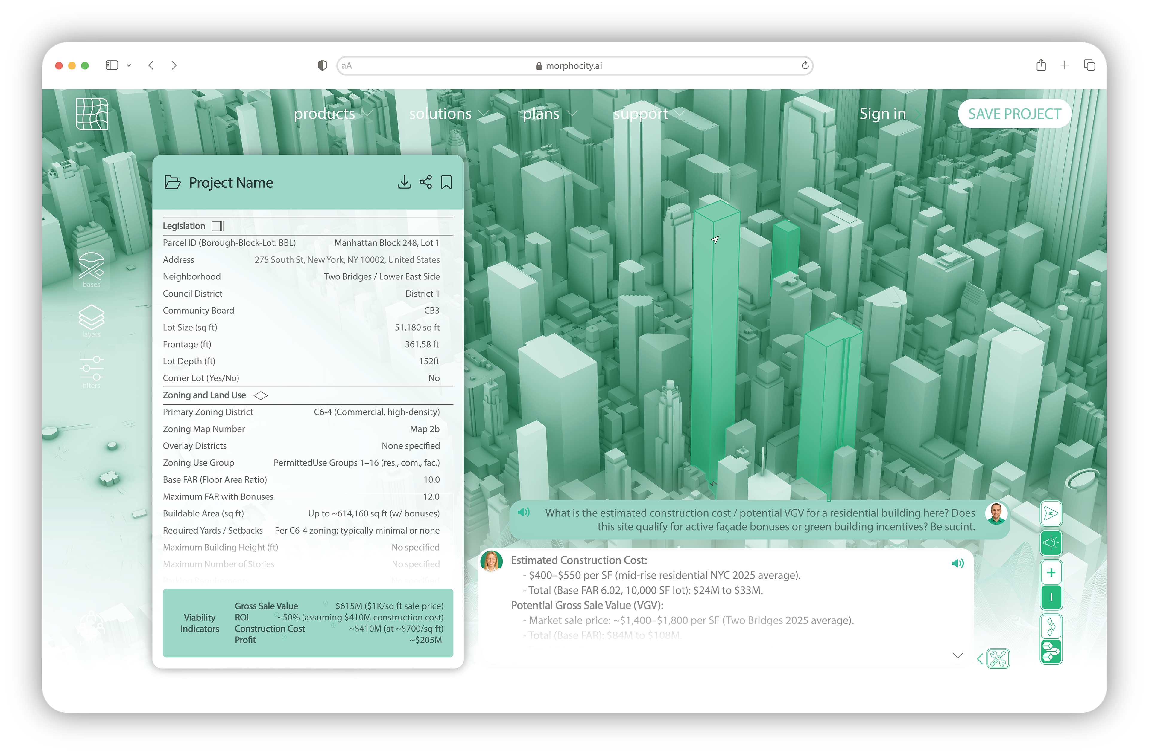
1. Simulate Massing and Envelope Options
– Test design iterations within zoning and urban design parameters.
– Test design iterations within zoning and urban design parameters.
2. Visualize Contextual Constraints
– Map out shadows, setbacks, height, and environmental overlays.
– Map out shadows, setbacks, height, and environmental overlays.
3. Access Layered City Data
– Integrate land use, infrastructure, and climate risks into early design.
– Integrate land use, infrastructure, and climate risks into early design.
4. Align with Policy and Community Goals
– Projects that meet planning codes and leverage urban incentives.
– Projects that meet planning codes and leverage urban incentives.
5. Collaborate with Real-Time Modeling
– Share interactive models with stakeholders for faster feedback.
– Share interactive models with stakeholders for faster feedback.
Solutions to Accelerate Development
1. Identify Buildable Potential
– Know what can be built on any parcel, instantly.
– Know what can be built on any parcel, instantly.
2. Calculate ROI and Land Value
– Estimate development value based on zoning, incentives, and comps.
– Estimate development value based on zoning, incentives, and comps.
3. Simulate Scenarios with Incentives
– Explore impact of affordable housing, green bonuses, or FAR boosts.
– Explore impact of affordable housing, green bonuses, or FAR boosts.
4. Forecast Project Timelines and Costs
– Incorporate permits, community processes, and approval windows.
– Incorporate permits, community processes, and approval windows.
5. De-risk Early Decisions
– Surface legal, environmental, and infrastructure flags before acquisition.
– Surface legal, environmental, and infrastructure flags before acquisition.

Solutions to Strengthen Planning
1. Visualize Zoning and Land-use
– Centralize up-to-date regulations & overlays on one dynamic map.
– Centralize up-to-date regulations & overlays on one dynamic map.
2. Target Areas for Growth or Protection
– Pinpoint zones for densification, preservation, or climate resilience.
– Pinpoint zones for densification, preservation, or climate resilience.
3. Evaluate Equity and Accessibility
– Layer social, economic, & environmental data for inclusive planning.
– Layer social, economic, & environmental data for inclusive planning.
4. Streamline Public Engagement
– Share clear, visual scenarios with communities and stakeholders.
– Share clear, visual scenarios with communities and stakeholders.
5. Simulate Policy Impact
– Model how zoning changes or incentives reshape neighborhoods.
– Model how zoning changes or incentives reshape neighborhoods.
Solutions for Climate Development
1. Map Environmental Hazards
– Understand flood, heat, storm, and sea level rise risk per parcel.
– Understand flood, heat, storm, and sea level rise risk per parcel.
2. Overlay Green Infrastructure
– Connect projects to transit, parks, and stormwater systems.
– Connect projects to transit, parks, and stormwater systems.
3. Check Environmental Compliance
– Surface legal overlays and site-specific constraints.
– Surface legal overlays and site-specific constraints.
4. Benchmark Carbon and Energy
– Estimate and compare emissions to local or global standards.
– Estimate and compare emissions to local or global standards.
5. Unlock Resilience Incentives
– Identify grants, credits, and zoning boosts for sustainable projects.
– Identify grants, credits, and zoning boosts for sustainable projects.


Solutions to Unlock Capital and Finance
1. Run Instant Feasibility Checks
– Assess land capacity and return potential before funding.
– Assess land capacity and return potential before funding.
2. Verify Entitlement and Zoning Risk
– Surface legal conditions and special district rules that affect approval.
– Surface legal conditions and special district rules that affect approval.
3. Compare Land Values and Market Comps
– Benchmark against similar parcels to price accurately.
– Benchmark against similar parcels to price accurately.
4. Structure Capital Stack Efficiently
– Estimate financing needs, subsidies, and sale prices per unit.
– Estimate financing needs, subsidies, and sale prices per unit.
5. Build Investor Confidence
– Share clean, clear development insights backed by real data.
– Share clean, clear development insights backed by real data.
"For years, we pushed the limits of design with Building Information Modeling, but Morphocity could takes it further. The idea brings the same clarity to entire cities. If you’re working on complex urban projects, this is the kind of tool that could redefine what’s possible at the intersection of data, design, and impact."
– Under Approval, Former BIM Leader at Bjarke Ingels Group.

Join our waitlist
Take the first step toward smarter city investments and planning. We’ll handle the rest.
© 2025 Morphocity. All rights reserved.